Posts

The Cat Island of Japan | Aoshima

Image
Aoshima, The Cat Island, is a small island, Ehime Prefecture, is unpretentious island in the Seto Inland Sea of Japan. “Cat Island,” as the locals call it, small places where there are significantly more feline residents than people and inhabited by 15 people and hundreds of cats. However, the 0.5 km² island does have one unique claim to fame–it’s known as a paradise for cats and cat lovers.  The island wasn’t always so deserted, nor was it known as being a “cat paradise.” Inhabitants of what is now Hyogo Prefecture first migrated to Aoshima approximately 380 years ago to fish the enormous numbers of sardines in the surrounding waters. Cats were initially introduced to the island to stop mice from chewing through fishing nets. The island experienced a peak population of 798 in 1955, but the number of people dwindled just as the population of cats multiplied.

Culture on Street Art in Social Media

Image
In a time where a lot of people are glued to their phones, this rings true, especially when you see people head down, walking into lamp posts on the way home from work because they can’t take their eyes off of their mobile device. iHeart a street-artist based in Vancouver, has created a series of street compositions in which each image examines our relationship to contemporary culture, social networks and their connection to a whole generation of children. Artist’s work is receiving a major boost from Banksy, the elusive yet famous British artist, after it was republished on his Facebook page and Istagram.

Giant Graffiti | The Dam of France

Image
The French duo graffiti artists Ella & Pitr is known for the size of their works. The Duo's most recent graphite is called Le Naufrage de Bienvenu , or "The Shipwreck of the Well-Vindos." It was made 47 meters high in a dam on the river Gier, and required ten days of work. Known for portraying neglected groups such as the homeless or the elderly, and paints them in difficult proportions to ignore, this time the two decided to address refugees seeking a better life in Europe. The character holds a photograph in his hand, just the sight of the dam where Ella and Pitr [Instagram] did the drawing.

Museum of science and technology, Netherlands

Image
Science Museum, the New Metropolis (NEMO) museum of science and technology, Netherlands. The name Science Center Nemo was introduced in 2000. The museum has its origins in 1923, The building was designed by renowned Italian architect Renzo Piano in 1997. The buildings that stand in the port of Amsterdam, NEMO emerges from the IJ river as a green building with a spectacular design. In 1923 when the "Museum of Labor" was opened by the artist Herman Heijenbrock on the Rozengracht in Amsterdam. In 1954 the name was changed to "Institute of Labor and Technology", and in 1997 it changed again to newMetropolis. The largest science center in the Netherlands with five floors of hands-on science exhibitions. It attracts more than 500,000 visitors yearly, it is the fifth most visited museum in the Netherlands. The main concepts on the first floor are DNA and chain reactions which include a room with giant dominoes with contraptions like a giant bell and a flying car. Als...

Eidi Stadium, Faroe Islands Pics

Image
Our previous post Lake Sørvágsvatn, the biggest lake of of the Faroe Islands.  Eidi Stadium is located just a few meters from the Atlantic Ocean, the venue for matches of semi-professional football team of the Faroe Islands. There is only a small amount of standing room for fans and balls often fly directly into the sea. The stadium is located in Eidi - town in the north-western tip of Eysturoy. Its name means "isthmus" in the Faroese language. The city has a population of 669 inhabitants. In the center of the village from 1881 there is a large stone church, which was built in connection with the centenary of the village.In the hills above Toftir is the football stadium, constructed especially for international football competitions. Beyond the stadium further up in the hills is the beautiful lake, Toftavatn. The view from on top affords a good view towards Tórshavn and the surrounding countryside.

Lakes of Ounianga in the Sahara Desert

Image
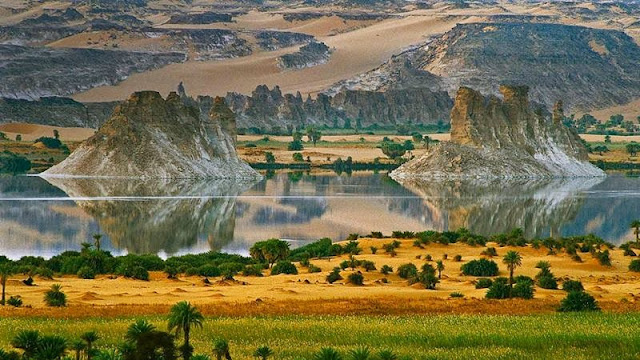
Lakes of Ounianga are a series of  18 lakes in the Sahara Desert, in North-Eastern Chad, occupying a basin in the mountains of West Tibesti and Ennedi East. The names of the lake groups are derived from the name of a village nearby. It was added as a UNESCO World Heritage site in 2012, the lakes are in a hot and hyper-arid desert that features a rainfall of less than 2 millimeters a year. The lakes are situated in a shallow basin below sandstone cliffs and hills, from where the ancient water flows.  Remarkably, this unique hydro-logical system is able to sustain the largest permanent freshwater lakes to be found in such an arid desert environment anywhere in the world. The lakes are remnants of a single large lake, probably tens of kilometers long, that once occupied this remote area approximately 14,800 to 5,500 years ago. As the climate dried out during the subsequent millennia, the lake shrank, and large, wind-driven sand dunes invaded the original depression, dividing...

Beautiful Ubari Lakes oasis in the Sahara desert

Image
Ubari Lakes in the Libyan part of the Sahara desert on the right are among the most beautiful oasis in the world. The largest of these is Lake Umm Al-Maa, which means "Mother of Waters." The water in it is very salty - concentration can be compared with the water of the Dead Sea. Uniqueness lake also consists in the fact that the lower layers is always very hot water, the temperature sometimes reaches to 100 degrees, and wherein the upper layers are cold. Ubari Lakes - a group of about 20 lakes of the landscape of high dunes and palm trees. To achieve these lakes, tourists usually go to Tkerkiba where excellent camping functions to explore the lake. Depth of the lakes, according to the Libyan Central diving varies from seven meters deep (as in Gabrun) up to 32 meters deep (Ain al-Dibbanah about Ghadames). Some of these lakes are drying up due to drought slowly and artificial drainage. Among the most picturesque lakes Gaberun and Umm al-Maa. Also there are two more beautif...

Giant Fingerprint Island of Croatia

Image
Croatia has 79 large islands, over 500 smaller islets and another 642 small rocky peaks and covering an area of about 3,300 square kilometers. Of these small islands is Baljenac or sound like Bavljenac, situated in front of the Dalmatian coast, to the south of country, and that forms part of Šibenik archipelago. It hardly has 0.14 square kilometers of surface and a length of coast of 1,431 meters.  It is uninhabited, but recently Croatia requested its inclusion in the list of UNESCO World Heritage sites. The stone walls of Baljenac island is an example of this story and tells us that, in the 16th and 17th centuries, during the Ottoman conquest, the island served as a refuge for the Christians who began to build, stone by stone, a network of walls to protect themselves although it would not be until the 19th century and thanks to the Agriculture, when it reached its current appearance that resembles a human fingerprint. Farmers on the nearby island of Kaprije ended up er...