Posts

Showing posts from June, 2018

Lakes of Ounianga in the Sahara Desert

Image
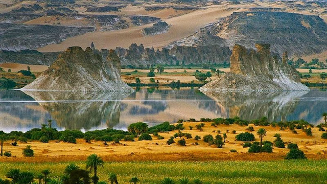
Lakes of Ounianga are a series of  18 lakes in the Sahara Desert, in North-Eastern Chad, occupying a basin in the mountains of West Tibesti and Ennedi East. The names of the lake groups are derived from the name of a village nearby. It was added as a UNESCO World Heritage site in 2012, the lakes are in a hot and hyper-arid desert that features a rainfall of less than 2 millimeters a year. The lakes are situated in a shallow basin below sandstone cliffs and hills, from where the ancient water flows.  Remarkably, this unique hydro-logical system is able to sustain the largest permanent freshwater lakes to be found in such an arid desert environment anywhere in the world. The lakes are remnants of a single large lake, probably tens of kilometers long, that once occupied this remote area approximately 14,800 to 5,500 years ago. As the climate dried out during the subsequent millennia, the lake shrank, and large, wind-driven sand dunes invaded the original depression, dividing it into

Beautiful Ubari Lakes oasis in the Sahara desert

Image
Ubari Lakes in the Libyan part of the Sahara desert on the right are among the most beautiful oasis in the world. The largest of these is Lake Umm Al-Maa, which means "Mother of Waters." The water in it is very salty - concentration can be compared with the water of the Dead Sea. Uniqueness lake also consists in the fact that the lower layers is always very hot water, the temperature sometimes reaches to 100 degrees, and wherein the upper layers are cold. Ubari Lakes - a group of about 20 lakes of the landscape of high dunes and palm trees. To achieve these lakes, tourists usually go to Tkerkiba where excellent camping functions to explore the lake. Depth of the lakes, according to the Libyan Central diving varies from seven meters deep (as in Gabrun) up to 32 meters deep (Ain al-Dibbanah about Ghadames). Some of these lakes are drying up due to drought slowly and artificial drainage. Among the most picturesque lakes Gaberun and Umm al-Maa. Also there are two more beautif

Giant Fingerprint Island of Croatia

Image
Croatia has 79 large islands, over 500 smaller islets and another 642 small rocky peaks and covering an area of about 3,300 square kilometers. Of these small islands is Baljenac or sound like Bavljenac, situated in front of the Dalmatian coast, to the south of country, and that forms part of Šibenik archipelago. It hardly has 0.14 square kilometers of surface and a length of coast of 1,431 meters.  It is uninhabited, but recently Croatia requested its inclusion in the list of UNESCO World Heritage sites. The stone walls of Baljenac island is an example of this story and tells us that, in the 16th and 17th centuries, during the Ottoman conquest, the island served as a refuge for the Christians who began to build, stone by stone, a network of walls to protect themselves although it would not be until the 19th century and thanks to the Agriculture, when it reached its current appearance that resembles a human fingerprint. Farmers on the nearby island of Kaprije ended up erecti